Dosya:Bombingen av Kristiansund, 1940, Riksarkivet, Arkivreferanse PA 1667U2 050.jpg
Orijinal dosya (4.090 × 2.704 piksel, dosya boyutu: 557 KB, MIME türü: image/jpeg)
Özet
| Açıklama |
Norsk bokmål: Beskrivelse:
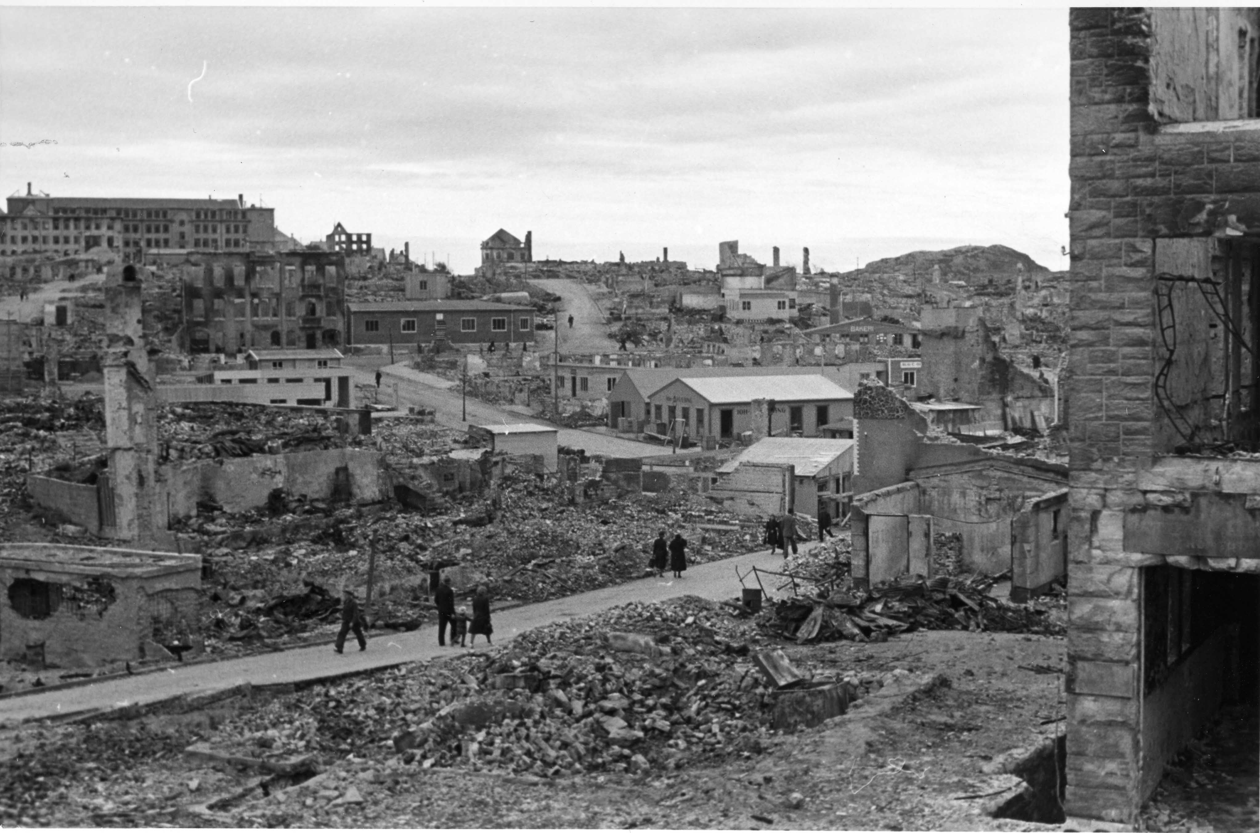
Den tyske invasjonen innebar at 24 byer og tettsteder i Norge ble bombet våren 1940. Det gjaldt bl.a. Molde, Kristiansund, Steinkjer og Namsos. Riksarkivet har mottatt 64 fotografier (papirpositiver 9 x 12 cm) som ifølge påskrift på konvolutten skal være tatt i juli 1940 i Kristiansund, Steinkjer og Levanger.
Takket være god hjelp har vi fått stedsbestemt mange av motivene, men ikke alle, og Riksarkivet mottar gjerne nærmere opplysninger. Arkivreferanse: PA-1667U2_050 The bombing of Kristiansund The German invasion resulted in 24 towns and villages being bombed in the spring of 1940. This included Molde, Kristiansund, Steinkjer and Namsos. The National Archives of Norway has received 64 photographs (paper positives 9 x 12 cm) that according to information on the envelope are taken in July 1940 in Kristiansund, Steinkjer and Levanger. The photos have belonged to engineer Hallvard Løken (1908-1995). He was a good amateur photographer and might very well have taken the photos himself. Thanks to help from others, we have been able to pinpoint many of the locations, but not all of them, and the National Archives of Norway is very happy to receive further information. |
| Tarih | |
| Kaynak | https://www.flickr.com/photos/national_archives_of_norway/6829235893/ |
| Yazar | Riksarkivet (National Archives of Norway) |
| Kamera pozisyonu | | Bu ve diğer görüntülerin konumlarını şurada belirle: OpenStreetMap |
|---|
Lisanslama
| This image was originally posted to Flickr. Its license was verified as "Flickr-no known copyright restrictions" by the UploadWizard Extension at the time it was transferred to Commons. See the license information for further details. |
This image was taken from Flickr's The Commons. The uploading organization may have various reasons for determining that no known copyright restrictions exist, such as:
More information can be found at https://flickr.com/commons/usage/. Please add additional copyright tags to this image if more specific information about copyright status can be determined. See Commons:Licensing for more information. |
Dosya geçmişi
Dosyanın herhangi bir zamandaki hâli için ilgili tarih/saat kısmına tıklayın.
| Tarih/Saat | Küçük resim | Boyutlar | Kullanıcı | Yorum | |
|---|---|---|---|---|---|
| güncel | 20.55, 2 Mayıs 2014 | | 4.090 × 2.704 (557 KB) | wikimediacommons>Anne-Sophie Ofrim | User created page with UploadWizard |
Dosya kullanımı
Aşağıdaki sayfa bu dosyayı kullanmaktadır: