Dosya:Ground Plan of Belfast (1685).png
Bu önizlemenin boyutu: 800 × 550 piksel. Diğer çözünürlükler: 320 × 220 piksel | 640 × 440 piksel | 1.024 × 705 piksel | 1.280 × 881 piksel | 2.560 × 1.761 piksel | 3.735 × 2.570 piksel.
Orijinal dosya (3.735 × 2.570 piksel, dosya boyutu: 10,07 MB, MIME türü: image/png)
Özet
| Açıklama |
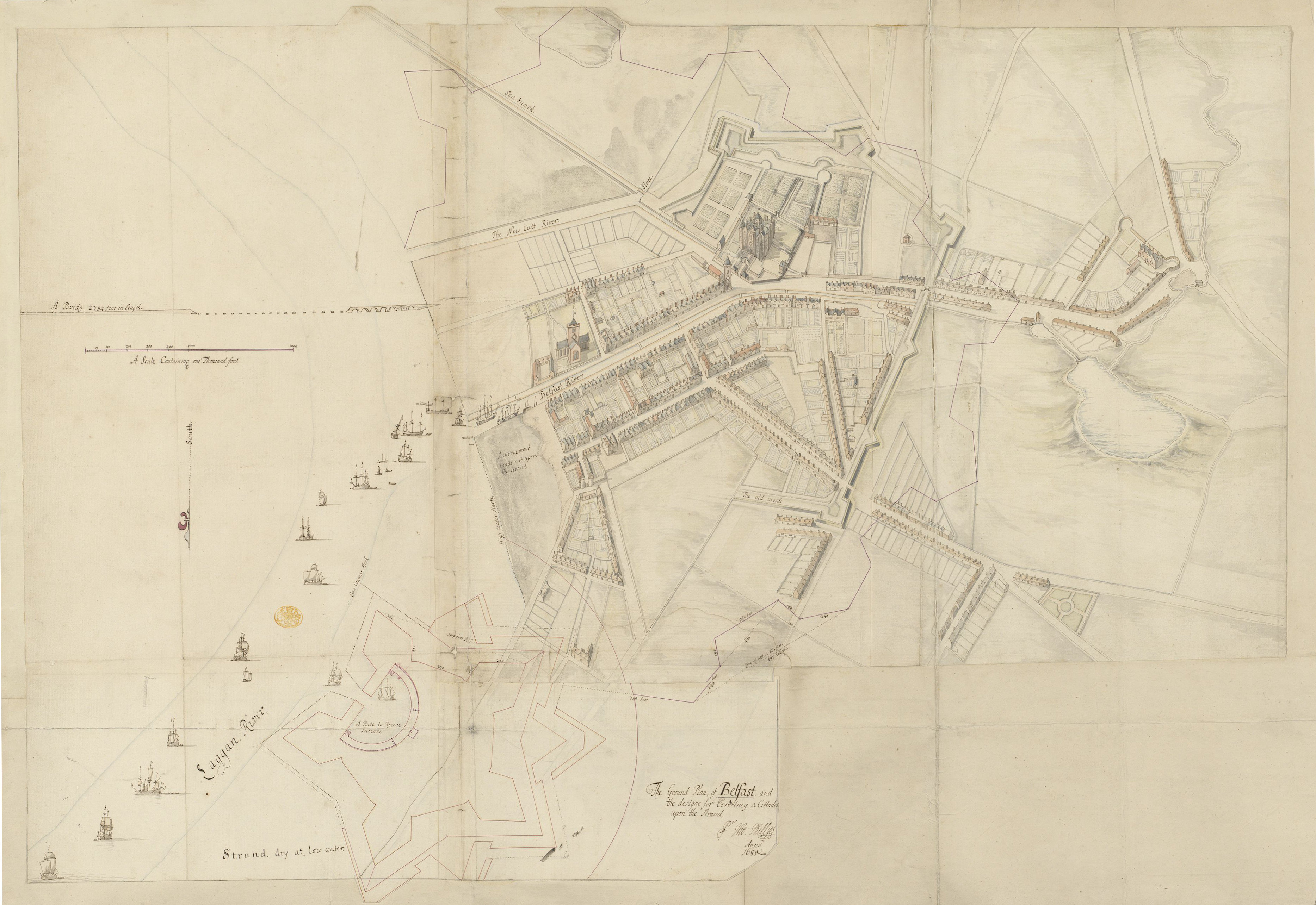
English: A pen and ink sketch of Belfast, prepared as part of Thomas Phillips' survey of Irish towns and fortifications. The town's existing ramparts are overlaid by a much grander scheme of Phillips' own devisal, with a plan for a citadel to the north. Landmarks include Belfast Castle and the Corporation Church, and the unfinished Long Bridge. The River Farset runs through the High Street and the Blackstaff flows over the slobland to the south, meeting the Lagan via the "new cutt". |
| Tarih | |
| Kaynak | The British Library King's Topographical Collection |
| Yazar | Thomas Phillips (d. 1693) |
| Diğer sürümler |
|
.png)
.png)
| Annotations | This image is annotated: View the annotations at Commons |
Lisanslama
|
Bu çalışma ABD'de veya yazarın yaşamının sona ermiş olmasından 70 veya daha fazla süre geçtiğinde bu duruma uygun telif yasaları olan tüm ülkelerde kamu malıdır. Bu çalışma 1 Ocak 1929 tarihinden önce yayımlanmıştır (veya ABD Telif Hakkı Ofisinde kayıtlıdır). Bu nedenle eser ABD'de kamu malıdır. | |
| Bu dosyanın, tüm ilgili ve komşu haklar da dâhil olmak üzere, telif hakkı yasası kapsamında bilinen kısıtlamalardan arınmış olduğu belirlendi. | |
Dosya geçmişi
Dosyanın herhangi bir zamandaki hâli için ilgili tarih/saat kısmına tıklayın.
| Tarih/Saat | Küçük resim | Boyutlar | Kullanıcı | Yorum | |
|---|---|---|---|---|---|
| güncel | 19.33, 16 Ocak 2021 | | 3.735 × 2.570 (10,07 MB) | wikimediacommons>Zacwill | Uploaded a work by {{w|Thomas Phillips (engineer)|Thomas Phillips}} (d. 1693) from https://flickr.com/photos/britishlibrary/50263987671 with UploadWizard |
Dosya kullanımı
Aşağıdaki sayfa bu dosyayı kullanmaktadır:
.png)