Dosya:Kuala Lumpur at dawn (18794580599).jpg

Orijinal dosya (7.360 × 4.912 piksel, dosya boyutu: 2,33 MB, MIME türü: image/jpeg)
.jpg)
Özet
| Açıklama |
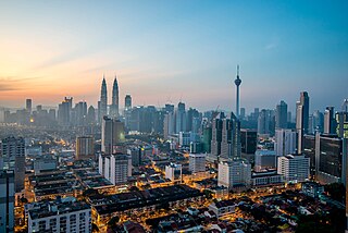
English: Kuala Lumpur is the national capital and most populous city in Malaysia. The city covers an area of 243 km2 and has an estimated population of 1.6 million as of 2010. Greater Kuala Lumpur, covering similar area as the Klang Valley, is an urban agglomeration of 7.5 million people as of 2012. It is among the fastest growing metropolitan regions in South-East Asia, in terms of population and economy.
Kuala Lumpur is the seat of the Parliament of Malaysia. The city was once home to the executive and judicial branches of the federal government, but they were moved to Putrajaya in early 1999. Some sections of the judiciary still remain in the capital city of Kuala Lumpur. The official residence of the Malaysian King, the Istana Negara, is also situated in Kuala Lumpur. Rated as an alpha world city, Kuala Lumpur is the cultural, financial and economic centre of Malaysia due to its position as the capital as well as being a key city. Kuala Lumpur was ranked 48th among global cities by Foreign Policy's 2010 Global Cities Index and was ranked 67th among global cities for economic and social innovation by the 2thinknow Innovation Cities Index in 2010. Since the 1990s, the city has played host to many international sporting, political and cultural events including the 1998 Commonwealth Games and the Formula One Grand Prix. In addition, Kuala Lumpur is home to the tallest twin buildings in the world, the Petronas Twin Towers, which have become an iconic symbol of Malaysia's futuristic development [Wikipedia.org] |
| Tarih | |
| Kaynak | Kuala Lumpur at dawn |
| Yazar | Jorge Láscar from Melbourne, Australia |
| Kamera pozisyonu | | Bu ve diğer görüntülerin konumlarını şurada belirle: OpenStreetMap |
|---|
.jpg¶ms=003.156242_N_0101.713056_E_globe:Earth_type:camera_source:Flickr_&language=tr)
Lisanslama
- Şu seçeneklerde özgürsünüz:
- paylaşım – eser paylaşımı, dağıtımı ve iletimi
- içeriği değiştirip uyarlama – eser adaptasyonu
- Aşağıdaki koşullar geçerli olacaktır:
- atıf – Esere yazar veya lisans sahibi tarafından belirtilen (ancak sizi ya da eseri kullanımınızı desteklediklerini ileri sürmeyecek bir) şekilde atıfta bulunmalısınız.
| This image was originally posted to Flickr by Jorge Lascar at https://flickr.com/photos/8721758@N06/18794580599 (archive). It was reviewed on 2 Şubat 2018 by FlickreviewR 2 and was confirmed to be licensed under the terms of the cc-by-2.0. |
Dosya geçmişi
Dosyanın herhangi bir zamandaki hâli için ilgili tarih/saat kısmına tıklayın.
| Tarih/Saat | Küçük resim | Boyutlar | Kullanıcı | Yorum | |
|---|---|---|---|---|---|
| güncel | 12.28, 2 Şubat 2018 | | 7.360 × 4.912 (2,33 MB) | wikimediacommons>Thesupermat2 | Transferred from Flickr via Flickr2Commons |
Dosya kullanımı
Aşağıdaki sayfa bu dosyayı kullanmaktadır:
.jpg)