Dosya:Locator map of Les Trois-Bassins 2018.png

Bu önizlemenin boyutu: 633 × 599 piksel. Diğer çözünürlükler: 254 × 240 piksel | 507 × 480 piksel | 811 × 768 piksel | 1.082 × 1.024 piksel | 2.164 × 2.048 piksel | 3.500 × 3.313 piksel.
Orijinal dosya (3.500 × 3.313 piksel, dosya boyutu: 680 KB, MIME türü: image/png)
Özet
| Açıklama |
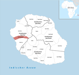
Deutsch: Lage der Gemeinde Les Trois-Bassins |
||||||||
| Tarih | |||||||||
| Kaynak | Yükleyenin kendi çalışması | ||||||||
| Yazar | Tschubby | ||||||||
| İzin (Bu dosyanın tekrar kullanımı) |
Ben, bu işin telif sahibi, burada işi aşağıdaki lisanslar altında yayımlıyorum:
Bu dosya Creative Commons Atıf-Benzer Paylaşım 2.5 Genel, 2.0 Genel ve 1.0 Genel lisansları ile lisanslanmıştır.
İstediğiniz lisansı seçebilirsiniz. |

Dosya geçmişi
Dosyanın herhangi bir zamandaki hâli için ilgili tarih/saat kısmına tıklayın.
| Tarih/Saat | Küçük resim | Boyutlar | Kullanıcı | Yorum | |
|---|---|---|---|---|---|
| güncel | 10.23, 29 Ekim 2018 | | 3.500 × 3.313 (680 KB) | wikimediacommons>Tschubby | == {{int:filedesc}} == {{Information |Description= {{de|Lage der Gemeinde Les Trois-Bassins}} |Source={{own}} |Date= 2018-01-01 |Author= Tschubby |Permission= {{self|GFDL|Cc-by-sa-3.0-migrated|Cc-by-sa-2.5,2.0,1.0}} |other_versions= }} Les Trois-Bassins |
Dosya kullanımı
Aşağıdaki sayfa bu dosyayı kullanmaktadır: