Dosya:Map of Hesse with districts (with numbers).svg

Bu SVG dosyasının PNG önizlemesinin boyutu: 403 × 542 piksel. Diğer çözünürlükler: 178 × 240 piksel | 357 × 480 piksel | 571 × 768 piksel | 761 × 1.024 piksel | 1.523 × 2.048 piksel.
Orijinal dosya (SVG dosyası, sözde 403 × 542 piksel, dosya boyutu: 77 KB)
.svg)
| Açıklama |
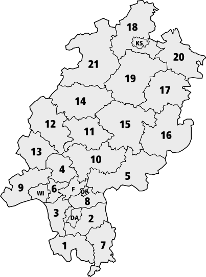
Deutsch: Karte Hessens mit den Grenzen der nummerierten Landkreise
English: Map of Hesse with borders of the numbered districts
|
| Kaynak | Official document [1], therefore public domain |
| Yazar |
| This image is in the public domain according to German copyright law because it is part of a statute, ordinance, official decree or judgment (official work) issued by a German authority or court (§ 5 Abs.1 UrhG).
|
 |
Dosya geçmişi
Dosyanın herhangi bir zamandaki hâli için ilgili tarih/saat kısmına tıklayın.
| Tarih/Saat | Küçük resim | Boyutlar | Kullanıcı | Yorum | |
|---|---|---|---|---|---|
| güncel | 22.35, 26 Ağustos 2006 | | 403 × 542 (77 KB) | wikimediacommons>Madden | {{Information |Description={{de|Karte Hessens mit den Grenzen der numerierten Landkreise}} {{en|Map of Hesse with borders of the numbered districts}} |Source=Official document [http://www.statistik-hessen.de/fileadmin/media/files/Flyer_Bevoelkerun |
Dosya kullanımı
Aşağıdaki sayfa bu dosyayı kullanmaktadır:
.svg)