Dosya:Map of Jupiter.jpg

bilgipedi.com.tr sitesinden

Orijinal dosya(2.231 × 2.266 piksel, dosya boyutu: 426 KB, MIME türü: image/jpeg)

Bu dosya Wikimedia Commons deposunda bulunmaktadır ve diğer projeler tarafından kullanılıyor olabilir. Aşağıda dosya açıklama sayfasındaki açıklama gösteriliyor.

Vikipedi

 Bu resim, İngilizce Vikipedi'de (Featured pictures) seçkin resim dosyasıdır ve en iyi resimlerden biri olarak seçilmiştir.

Eğer bu dosyanın Vikimedya Ortak Alanında (Wikimedia Commons) seçkin resim olabileceğini düşünüyorsanız, aday göstermekten çekinmeyiniz.
Buna benzeyen kalitede uygun bir lisans sözleşmesi altında bulunan resminiz var ise onu muhakkak yükleyiniz, etiketleyiniz ve aday gösteriniz.

Özet

Açıklama
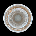
English: :This map of Jupiter is the most detailed global color map of the planet ever produced. The round map is a polar stereographic projection that shows the south pole in the center of the map and the equator at the edge. It was constructed from images taken by Cassini on Dec. 11 and 12, 2000, as the spacecraft neared Jupiter during a flyby on its way to Saturn. The map shows a variety of colorful cloud features, including parallel reddish-brown and white bands, the Great Red Spot, multi-lobed chaotic regions, white ovals and many small vortices. Many clouds appear in streaks and waves due to continual stretching and folding by Jupiter's winds and turbulence. The bluish-gray features along the north edge of the central bright band are equatorial "hot spots," meteorological systems such as the one entered by NASA's Galileo probe. Small bright spots within the orange band north of the equator are lightning-bearing thunderstorms. The polar region shown here is less clearly visible because Cassini viewed it at an angle and through thicker atmospheric haze.
Tarih 11-12 December 2000
Kaynak From http://www.nasa.gov/multimedia/imagegallery/image_feature_539.html
Yazar NASA/JPL/Space Science Institute
İzin
(Bu dosyanın tekrar kullanımı)
PD-USGOV-NASA.
Diğer sürümler

Lisanslama

Public domain Bu dosya NASA tarafından üretildiği için kamu malıdır. Aksi belirtilmediği sürece "NASA tarafından üretilen malzemenin telif hakkı olmadığı" NASA telif politikasında belirtilmiştir. (Bkz. Template:PD-USGov, NASA copyright policy page veya JPL Image Use Policy.)
Uyarılar:

Altyazılar

Bu dosyanın temsil ettiği şeyin tek satırlık açıklamasını ekleyin.

Bu dosyada gösterilen öğeler

betimlenen

Dosya geçmişi

Dosyanın herhangi bir zamandaki hâli için ilgili tarih/saat kısmına tıklayın.

Tarih/SaatKüçük resimBoyutlarKullanıcıYorum
güncel11.59, 14 Şubat 200711.59, 14 Şubat 2007 tarihindeki sürümün küçültülmüş hâli2.231 × 2.266 (426 KB)wikimediacommons>Helix84{{en| :This map of Jupiter is the most detailed global color map of the planet ever produced. The round map is a polar stereographic projection that shows the south pole in the center of the map and the equator at the edge. It was constructed from images

Aşağıdaki sayfa bu dosyayı kullanmaktadır:

Meta veri