Dosya:Map of North America with the Western Interior Seaway during the Campanian (Upper Cretaceous).png

Bu önizlemenin boyutu: 488 × 600 piksel. Diğer çözünürlükler: 195 × 240 piksel | 390 × 480 piksel | 625 × 768 piksel | 833 × 1.024 piksel | 1.945 × 2.391 piksel.
Orijinal dosya (1.945 × 2.391 piksel, dosya boyutu: 3,95 MB, MIME türü: image/png)
.png)
Özet
| Açıklama |
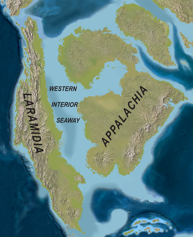
English: Map of North America with the Western Interior Seaway during the Campanian (Upper Cretaceous). Paleogeography of North America during the late Campanian Stage of the Late Cretaceous (∼75 Ma). Modified after Blakey.
Deutsch: Karte von Nordamerika mit dem Western Interior Seaway während des Campaniums (Obere Kreide) |
| Tarih | |
| Kaynak | http://www.plosone.org/article/info%3Adoi%2F10.1371%2Fjournal.pone.0012292 |
| Yazar | Scott D. Sampson, Mark A. Loewen, Andrew A. Farke, Eric M. Roberts, Catherine A. Forster, Joshua A. Smith, Alan L. Titus |
| İzin (Bu dosyanın tekrar kullanımı) |
http://www.plosbiology.org/static/license.action |
Lisanslama
Bu dosya Creative Commons Atıf 4.0 Uluslararası lisansı altında lisanslanmıştır.
- Şu seçeneklerde özgürsünüz:
- paylaşım – eser paylaşımı, dağıtımı ve iletimi
- içeriği değiştirip uyarlama – eser adaptasyonu
- Aşağıdaki koşullar geçerli olacaktır:
- atıf – Esere yazar veya lisans sahibi tarafından belirtilen (ancak sizi ya da eseri kullanımınızı desteklediklerini ileri sürmeyecek bir) şekilde atıfta bulunmalısınız.
Dosya geçmişi
Dosyanın herhangi bir zamandaki hâli için ilgili tarih/saat kısmına tıklayın.
| Tarih/Saat | Küçük resim | Boyutlar | Kullanıcı | Yorum | |
|---|---|---|---|---|---|
| güncel | 23.08, 1 Nisan 2020 | | 1.945 × 2.391 (3,95 MB) | wikimediacommons>FunkMonk | {{Information |Description = {{en|1=Map of North America with the Western Interior Seaway during the Campanian (Upper Cretaceous). Paleogeography of North America during the late Campanian Stage of the Late Cretaceous (∼75 Ma). Modified after Blakey.}} {{de|1=Karte von Nordamerika mit dem Western Interior Seaway während des Campaniums (Obere Kreide)}} |Source =http://www.plosone.org/article/info%3Adoi%2F10.1371%2Fjournal.pone.0012292 |Author =Scott D. Sampson, Mark A. Loewe... |
Dosya kullanımı
Aşağıdaki sayfa bu dosyayı kullanmaktadır:
.png)