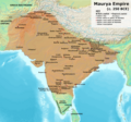
Dosya:Maurya Empire, c.250 BCE 2.png
bilgipedi.com.tr sitesinden

Bu önizlemenin boyutu: 642 × 600 piksel. Diğer çözünürlükler: 257 × 240 piksel | 514 × 480 piksel | 822 × 768 piksel | 1.200 × 1.121 piksel.
Orijinal dosya (1.200 × 1.121 piksel, dosya boyutu: 2,26 MB, MIME türü: image/png)
Bu dosya Wikimedia Commons deposunda bulunmaktadır ve diğer projeler tarafından kullanılıyor olabilir. Aşağıda dosya açıklama sayfasındaki açıklama gösteriliyor.
Özet
| AçıklamaMaurya Empire, c.250 BCE 2.png |
English: Note: This was the standard "textbook" map of the Maurya Empire. Historians are now arguing that the Maurya Empire did not include large parts of India, which were controlled by autonomous tribes. For such a map, see File:Maurya Empire, c.250 BCE.png.
 Boundaries are based on Charles Joppen Historical Atlas of India (1907), see File:India_in_250_B._C.jpg. Other Sources:
Other sources:
Notes:
|
| Tarih | |
| Kaynak | Yükleyenin kendi çalışması |
| Yazar | Avantiputra7 |
Lisanslama
Ben, bu işin telif sahibi, burada işi aşağıdaki lisans altında yayımlıyorum:
Bu dosya, Creative Commons Atıf-Benzer Paylaşım 3.0 Taşınmamış lisansı ile lisanslanmıştır
- Şu seçeneklerde özgürsünüz:
- paylaşım – eser paylaşımı, dağıtımı ve iletimi
- içeriği değiştirip uyarlama – eser adaptasyonu
- Aşağıdaki koşullar geçerli olacaktır:
- atıf – Esere yazar veya lisans sahibi tarafından belirtilen (ancak sizi ya da eseri kullanımınızı desteklediklerini ileri sürmeyecek bir) şekilde atıfta bulunmalısınız.
- benzer paylaşım – Maddeyi yeniden karıştırır, dönüştürür veya inşa ederseniz, katkılarınızı orijinal olarak aynı veya uyumlu lisans altında dağıtmanız gerekir.
Altyazılar
Bu dosyanın temsil ettiği şeyin tek satırlık açıklamasını ekleyin.
Extents of mauryan empire
Bu dosyada gösterilen öğeler
betimlenen
Vikiveri ögesi olmayan bir değer
3 Temmuz 2014
image/png
Dosya geçmişi
Dosyanın herhangi bir zamandaki hâli için ilgili tarih/saat kısmına tıklayın.
| Tarih/Saat | Küçük resim | Boyutlar | Kullanıcı | Yorum | |
|---|---|---|---|---|---|
| güncel | 10.27, 27 Haziran 2024 |  | 1.200 × 1.121 (2,26 MB) | wikimediacommons>Avantiputra7 | Reverted to version as of 11:01, 30 April 2024 (UTC) - vandalism |
Dosya kullanımı
Aşağıdaki sayfa bu dosyayı kullanmaktadır:
Meta veri
Bu dosyada, muhtemelen fotoğraf makinesi ya da tarayıcı tarafından eklenmiş ek bilgiler mevcuttur. Eğer dosyada sonradan değişiklik yapıldıysa, bazı bilgiler yeni değişikliğe göre eski kalmış olabilir.
| Yatay çözünürlük | 28,35 dpc |
|---|---|
| Dikey çözünürlük | 28,35 dpc |
"http://bilgipedi.com.tr/wiki/Dosya:Maurya_Empire,_c.250_BCE_2.png" sayfasından alınmıştır