Dosya:Population Density by Pakistani District - 2017 Census.svg

Orijinal dosya (SVG dosyası, sözde 3.200 × 2.000 piksel, dosya boyutu: 2,43 MB)
Özet
| Açıklama |
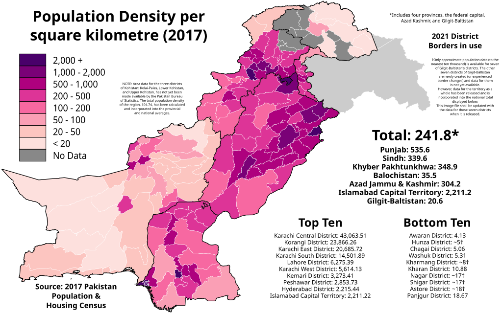
English: The map above shows the population density (per square kilometre) of each Pakistani district according to the final official results of the 2017 Pakistan Population & Housing Census. The data can be found here for the four provinces and ICT, here for Azad Kashmir, and here for Gilgit-Baltistan.
NOTE: Only approximate data (to the nearest ten thousand) is available for seven of Gilgit-Baltistan's districts. The other seven districts of Gilgit-Baltistan are newly created (or experienced border changes) and data for them is not yet available. However, data for the territory as a whole has been released and is incorporated into the national total displayed below. This image file shall be updated with the data for those seven districts when it is released. NOTE: Area data for the three districts of Kohistan: Kolai-Palas, Lower Kohistan, and Upper Kohistan, has not yet been made available by the Pakistan Bureau of Statistics. The total population density of the region, 104.74, has been calculated and incorporated into the provincial and national averages. Legend 2,000+
1,000 - 1,500
500 - 1,000
200 - 500
100 - 200
50 - 100
20 - 50
< 20 |
| Tarih | |
| Kaynak |
Bu dosya şu kaynaktan türetilmiştir: Blank Districts of Pakistan.svg: |
| Yazar | Abbasi786786 |
Lisanslama
- Şu seçeneklerde özgürsünüz:
- paylaşım – eser paylaşımı, dağıtımı ve iletimi
- içeriği değiştirip uyarlama – eser adaptasyonu
- Aşağıdaki koşullar geçerli olacaktır:
- atıf – Esere yazar veya lisans sahibi tarafından belirtilen (ancak sizi ya da eseri kullanımınızı desteklediklerini ileri sürmeyecek bir) şekilde atıfta bulunmalısınız.
- benzer paylaşım – Maddeyi yeniden karıştırır, dönüştürür veya inşa ederseniz, katkılarınızı orijinal olarak aynı veya uyumlu lisans altında dağıtmanız gerekir.
Dosya geçmişi
Dosyanın herhangi bir zamandaki hâli için ilgili tarih/saat kısmına tıklayın.
| Tarih/Saat | Küçük resim | Boyutlar | Kullanıcı | Yorum | |
|---|---|---|---|---|---|
| güncel | 17.42, 20 Mart 2022 | | 3.200 × 2.000 (2,43 MB) | wikimediacommons>Abbasi786786 | Fix typo |
Dosya kullanımı
Aşağıdaki sayfa bu dosyayı kullanmaktadır: