Dosya:Shatt al-Basra.jpg

Orijinal dosya (7.500 × 5.000 piksel, dosya boyutu: 19,05 MB, MIME türü: image/jpeg)
Özet
| Açıklama |
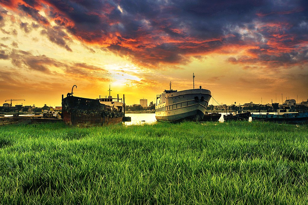
English: Shatt al-Arab was named Tigris al-Awra, a river consisting of the confluence of the Tigris and Euphrates Rivers, where the rivers meet in the region (Kerma Ali) the northern entrance to the city of Basra, while they meet in the city of Qurna, 375 km south of Baghdad. It is about 190 km long and is located in the Arabian Gulf at the edge of Al Faw city, which is the most extreme point in southern Iraq, and the Shatt al-Arab offer in some areas to 2 km. As for its flora, all were planted with palm trees before the war but were cut and neglected during the last period , And there is a beautiful city located on the banks of the Shatt al-Arab called Altnump where there are abundant palm groves and when the University of Basra was built in this city with its stunning views and charming nature and continues the river in the path until passing the Abu Al-Khasib, a region rich with palm trees, a rural area .
Until 1975, all the Shatt al-Arab waters were part of Iraq, but under the Algiers agreement, Iraq relinquished the eastern coast bordering Iran. Navigation became common. It is the intention of the local government in the city of Basra to make the island of Umm al-Rasat overlooking the Shat tourist area, but did not actually begin the completion of the project and on a related scale has expanded the talk recently about the growing phenomenon of pollution of the Shatt al-Arab water and there are speaking with experience in the field of environmental protection for the existence of Oil stains in some areas of water from the river, and the Shatt al-Arab from the deepest water bodies in Iraq, where large vessels can walk through to inside Iraq. The branch of the Shatt al-Arab River is divided into many marshes that divide the cities and the visual districts, forming one of the sweetest scenes in Basra. The local government in Basra has developed the Sayab Corniche, named after Basra poet Badr Shaker al-Sayab and Cornish Palace on the banks of the Shatt al- Occasionsالعربية: شط العرب وكان اسمه دجلة العوراء، هو نهر يتكون من التقاء نهري دجلة والفرات، حيث يلتقي النهران في منطقة (كرمة علي) المدخل الشمالي لمدينة البصرة في حين كانا يلتقيان في مدينة القرنة على بعد 375 كم جنوب بغداد. ويبلغ طوله حوالي 190 كم، ويصب في الخليج العربي عند طرف مدينة الفاو، والتي تعتبر أقصى نقطة في جنوب العراق ويصل عرض شط العرب في بعض مناطقه إلى 2 كيلو متر أما بالنسبة لضفافهِ فكانت كلها مزروعة بأشجار النخيل قبل الحرب ولكنها تعرضت للقطع والأهمال خلال الفترة الأخيرة، وهناك مدينة جميلية تقع على ضفاف شط العرب تسمى التنومة حيث تكثر فيها بساتين النخيل وعندما تم بناء جامعة البصرة كانت في هذه المدينة بما تتمع بها من مناظر خلابة وطبيعة ساحرة ويستمر النهر في المسير حتى يمر بقضاء أبي الخصيب وهي منطقة عامرة باشجار النخيل وهي منطقة ريفية.
الشجرة التين والأغنامكانت كل مياه شط العرب حتى عام 1975 جزء من العراق، الا انه وبموجب اتفاقية الجزائر تنازل العراق على الشاطيء الشرقي المطل على الحدود مع إيران لها. وأصبحت الملاحة مشتركة. وهناك نية لدى الحكومة المحلية في مدينة البصرة بأن تجعل جزيرة أم الرصاص المطلة على الشط منطقة سياحية ولكنها لم تباشر فعليا بأنجاز المشروع وعلى صعيد متصل اتسعت رقعة الحديث مؤخرا حول تفاقم ظاهرة تلوث مياه شط العرب وهناك من يتحدث من ذوي الخبرة في مجال حماية البيئة عن وجود بقع زيت في بعض المساحات المائية من النهر، ويعتبر شط العرب من أعمق المسطحات المائية في العراق حيث تستطيع السفن الكبيرة في السير من خلاله إلى داخل العراق. ويتفرع من نهر شط العرب الكثير من الأهوار التي تشق المدن والأحياء البصرية فتشكل إحدى أحلى المناظر في البصرة، ولقد طورت الحكومة المحلية في البصرة كورنيش السياب الذي سمي على اسم شاعر البصرة بدر شاكر السياب وكورنيش القصر على ضفاف شط العرب حيث يشهد حضور العديد من السائحين في المناسبات |
| Tarih | |
| Kaynak | Yükleyenin kendi çalışması |
| Yazar | Mohammed Abdul Hussein |
It is the intention of the local government in the city of Basra to make the island of Umm al-Rasat overlooking the Shat tourist area, but did not actually begin the completion of the project and on a related scale has expanded the talk recently about the growing phenomenon of pollution of the Shatt al-Arab water and there are speaking with experience in the field of environmental protection for the existence of Oil stains in some areas of water from the river, and the Shatt al-Arab from the deepest water bodies in Iraq, where large vessels can walk through to inside Iraq.
Lisanslama
- Şu seçeneklerde özgürsünüz:
- paylaşım – eser paylaşımı, dağıtımı ve iletimi
- içeriği değiştirip uyarlama – eser adaptasyonu
- Aşağıdaki koşullar geçerli olacaktır:
- atıf – Esere yazar veya lisans sahibi tarafından belirtilen (ancak sizi ya da eseri kullanımınızı desteklediklerini ileri sürmeyecek bir) şekilde atıfta bulunmalısınız.
- benzer paylaşım – Maddeyi yeniden karıştırır, dönüştürür veya inşa ederseniz, katkılarınızı orijinal olarak aynı veya uyumlu lisans altında dağıtmanız gerekir.
Bu resim Viki Yeryüzünü Seviyor 2017‘nin bir parçası olarak yüklendi.
|
 |
Dosya geçmişi
Dosyanın herhangi bir zamandaki hâli için ilgili tarih/saat kısmına tıklayın.
| Tarih/Saat | Küçük resim | Boyutlar | Kullanıcı | Yorum | |
|---|---|---|---|---|---|
| güncel | 19.17, 12 Mayıs 2017 | | 7.500 × 5.000 (19,05 MB) | wikimediacommons>Mohammed Abdul Hussein | User created page with UploadWizard |
Dosya kullanımı
Aşağıdaki sayfa bu dosyayı kullanmaktadır: