Dosya:Soufriere Hills Volcano dome collapse.gif

Bu önizlemenin boyutu: 600 × 600 piksel. Diğer çözünürlükler: 240 × 240 piksel | 480 × 480 piksel | 768 × 768 piksel | 1.024 × 1.024 piksel | 1.791 × 1.791 piksel.
Orijinal dosya (1.791 × 1.791 piksel, dosya boyutu: 1,27 MB, MIME türü: image/gif, döngüye girdi, 2 kare, 4,0 sn)
Özet
| Açıklama |
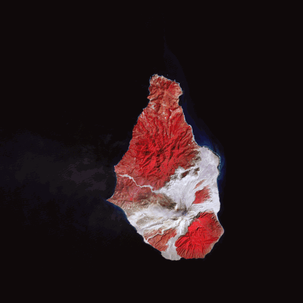
English: These false-colour satellite images show the southern half of Montserrat before and after its dome collapsed. Red areas are vegetated, clouds are white, blue/black areas are ocean water, and grey areas are covered by flow deposits. Fresh deposits tend to be lighter than older deposits. the drainages leading down from Soufrière Hills, including the White River Valley, the Tar River Valley, and the Belham River Valley, were filled with fresh debris. |
| Tarih | |
| Kaynak | NASA Earth Observatory |
| Yazar | Robert Simmon |
Images created using data from the NASA/GSFC/METI/ERSDAC/JAROS, and U.S./Japan ASTER Science Team. Instrument: Terra - ASTER.
Lisanslama
| Bu dosya NASA tarafından üretildiği için kamu malıdır. Aksi belirtilmediği sürece "NASA tarafından üretilen malzemenin telif hakkı olmadığı" NASA telif politikasında belirtilmiştir. (Bkz. Template:PD-USGov, NASA copyright policy page veya JPL Image Use Policy.) | ||
 |
Uyarılar:
|
| Annotations | This image is annotated: View the annotations at Commons |
Dosya geçmişi
Dosyanın herhangi bir zamandaki hâli için ilgili tarih/saat kısmına tıklayın.
| Tarih/Saat | Küçük resim | Boyutlar | Kullanıcı | Yorum | |
|---|---|---|---|---|---|
| güncel | 12.46, 26 Şubat 2010 | | 1.791 × 1.791 (1,27 MB) | wikimediacommons>Originalwana | {{Information |Description={{en|1=These false-colour satellite images show the southern half of Montserrat before and after its dome collapsed. Red areas are vegetated, clouds are white, blue/black areas are ocea |
Dosya kullanımı
Aşağıdaki sayfa bu dosyayı kullanmaktadır: