Dosya:1947-UN-Partition-Plan-1949-Armistice-Comparison.svg

Orijinal dosya (SVG dosyası, sözde 367 × 1.029 piksel, dosya boyutu: 48 KB)
Bu dosya Wikimedia Commons deposunda bulunmaktadır ve diğer projeler tarafından kullanılıyor olabilir. Aşağıda dosya açıklama sayfasındaki açıklama gösteriliyor.
Özet
| Açıklama1947-UN-Partition-Plan-1949-Armistice-Comparison.svg |
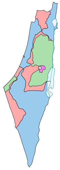
English: Comparison between the boundaries in the November 29th 1947 United Nations General Assembly partition plan (Resolution 181) for the British Mandate Territory of Palestine and the eventual armistice boundaries of 1949-1950. The meaning of the map colors is as follows (a legend caption is available in template form here):
Some limitations of the map:
|
| Tarih | |
| Kaynak | This is a partial SVG conversion (omitting text) of the original PostScript vector source of raster Image:1947-UN-Partition-Plan-1949-Armistice-Comparison.png by User:AnonMoos. Apparently, http://unispal.un.org/UNISPAL.NSF/0/651C804E6815FB28852575DF004B7C4C, ANNEX II, is the ultimate (UN) source. |
| Yazar | AnonMoos |
| Diğer sürümler |
Bu dosyanın türev çalışmaları: Palaestina 1947.svg[değiştir]
|
Lisanslama
| Public domainPublic domainfalsefalse |
| Bu iş yazarı AnonMoos tarafından kamu malı olarak yayınlanmıştır. Bu dünya çapında geçerlidir. Bazı ülkelerde bu yasal olarak mümkün olmayabilir; öyleyse: |
Altyazılar
Bu dosyada gösterilen öğeler
betimlenen
Vikiveri ögesi olmayan bir değer
13 Temmuz 2007
image/svg+xml
61992d864cc3b969cdb625ec1db7016f01f9017f
49.350 bayt
1.029 piksel
367 piksel
Dosya geçmişi
Dosyanın herhangi bir zamandaki hâli için ilgili tarih/saat kısmına tıklayın.
| Tarih/Saat | Küçük resim | Boyutlar | Kullanıcı | Yorum | |
|---|---|---|---|---|---|
| güncel | 21.38, 8 Kasım 2013 | 367 × 1.029 (48 KB) | wikimediacommons>Ori~ | Reverted to version as of 16:16, 7 May 2013 |
Dosya kullanımı
Aşağıdaki sayfa bu dosyayı kullanmaktadır:
Meta veri
Bu dosyada, muhtemelen fotoğraf makinesi ya da tarayıcı tarafından eklenmiş ek bilgiler mevcuttur. Eğer dosyada sonradan değişiklik yapıldıysa, bazı bilgiler yeni değişikliğe göre eski kalmış olabilir.
| Kısa başlık | Comparison between the boundaries in the November 29th 1947 United Nations General Assembly partition plan (Resolution 181) for the British Mandate Territory of Palestine and the eventual armistice boundaries of 1949-1950. |
|---|---|
| Genişlik | 367 |
| Yükseklik | 1029 |


