Dosya:20170807 Bolivia 1373 crop Potosí sRGB (37270469644).jpg
Orijinal dosya (2.700 × 3.599 piksel, dosya boyutu: 1,61 MB, MIME türü: image/jpeg)
.jpg)
Özet
| Açıklama |
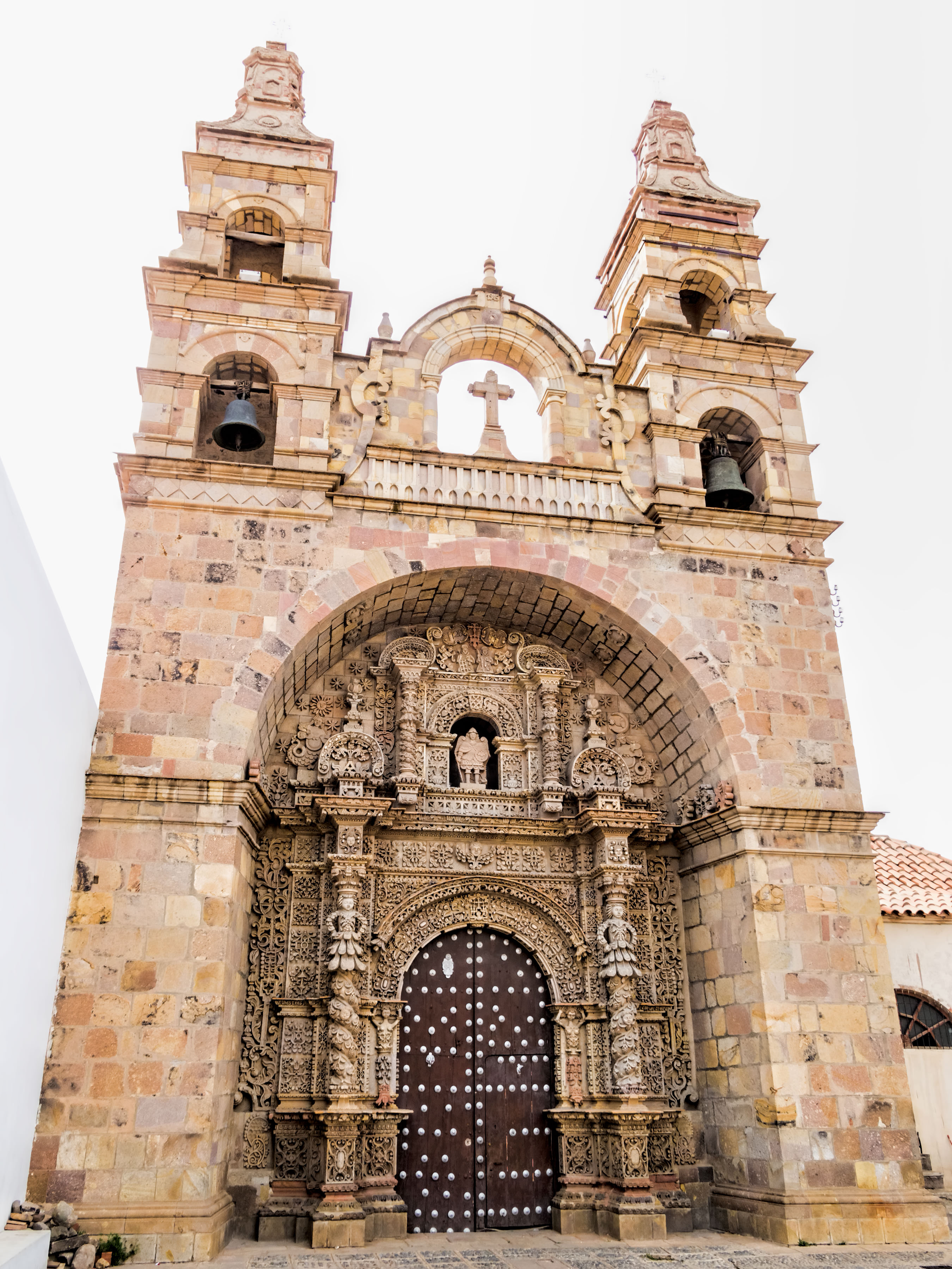
The Church of St. Lawrence of Carangas was built by indigenous people from Carangas, Bolivia, to be their parish church. They had been brought to Potosí to be forced laborers in the silver mine. Construction began in 1548. The church boasts an ornate entrance portal carved in stone by indigenous artisans in a mestizo baroque style. The bell towers were added during extensive remodeling from 1728 to 1744. A renovation was done in 1987. Potosí (elev. 4,090m/13,420ft) [for comparison: Lhasa, Tibet, at 3,658m/12,001ft] was founded in 1545 as a mining town at the foot of Rich Hill (Cerro Rico), the world’s largest silver deposit. An estimated 60% of all silver mined in the world during the second half of the 16th century came from Potosí which was reputed to be the world’s largest industrial complex at the time. Its population eventually exceeded 200,000 people, making it one of the largest cities in the world. Most of the mining and smelting (using mercury) was done by forced labor, both indigenous people and African slaves. As many as 8 million workers are estimated to have died between 1545 and 1825. Output began to decline in the early 19th century. By the 1890s, low silver prices prompted a shift to mining tin. Growing demand for tin this century by the electronics industry has helped the local economy. Silver extraction continues on a small scale. Miguel de Cervantes’ novel “Don Quixote” describes Potosí as a land of “extraordinary richness” (chapter 71 in the second volume which was published in 1615). The City of Potosí was declared a UNESCO World Heritage Site in 1987. On Google Earth: Iglesia de San Lorenzo de Carangas 19°35'12.12"S, 65°45'17.50"W |
| Tarih | |
| Kaynak | 20170807_Bolivia_1373 crop Potosí sRGB |
| Yazar | Dan Lundberg |
| Kamera pozisyonu | | Bu ve diğer görüntülerin konumlarını şurada belirle: OpenStreetMap |
|---|
.jpg¶ms=-19.586936_N_-065.754826_E_globe:Earth_type:camera_source:Flickr_&language=tr)
Lisanslama
- Şu seçeneklerde özgürsünüz:
- paylaşım – eser paylaşımı, dağıtımı ve iletimi
- içeriği değiştirip uyarlama – eser adaptasyonu
- Aşağıdaki koşullar geçerli olacaktır:
- atıf – Esere yazar veya lisans sahibi tarafından belirtilen (ancak sizi ya da eseri kullanımınızı desteklediklerini ileri sürmeyecek bir) şekilde atıfta bulunmalısınız.
- benzer paylaşım – Maddeyi yeniden karıştırır, dönüştürür veya inşa ederseniz, katkılarınızı orijinal olarak aynı veya uyumlu lisans altında dağıtmanız gerekir.
| This image was originally posted to Flickr by Dan Lundberg at https://flickr.com/photos/9508280@N07/37270469644 (archive). It was reviewed on 2 Kasım 2017 by FlickreviewR 2 and was confirmed to be licensed under the terms of the cc-by-sa-2.0. |
Dosya geçmişi
Dosyanın herhangi bir zamandaki hâli için ilgili tarih/saat kısmına tıklayın.
| Tarih/Saat | Küçük resim | Boyutlar | Kullanıcı | Yorum | |
|---|---|---|---|---|---|
| güncel | 17.58, 2 Kasım 2017 | | 2.700 × 3.599 (1,61 MB) | wikimediacommons>Ser Amantio di Nicolao | Transferred from Flickr via Flickr2Commons |
.jpg)