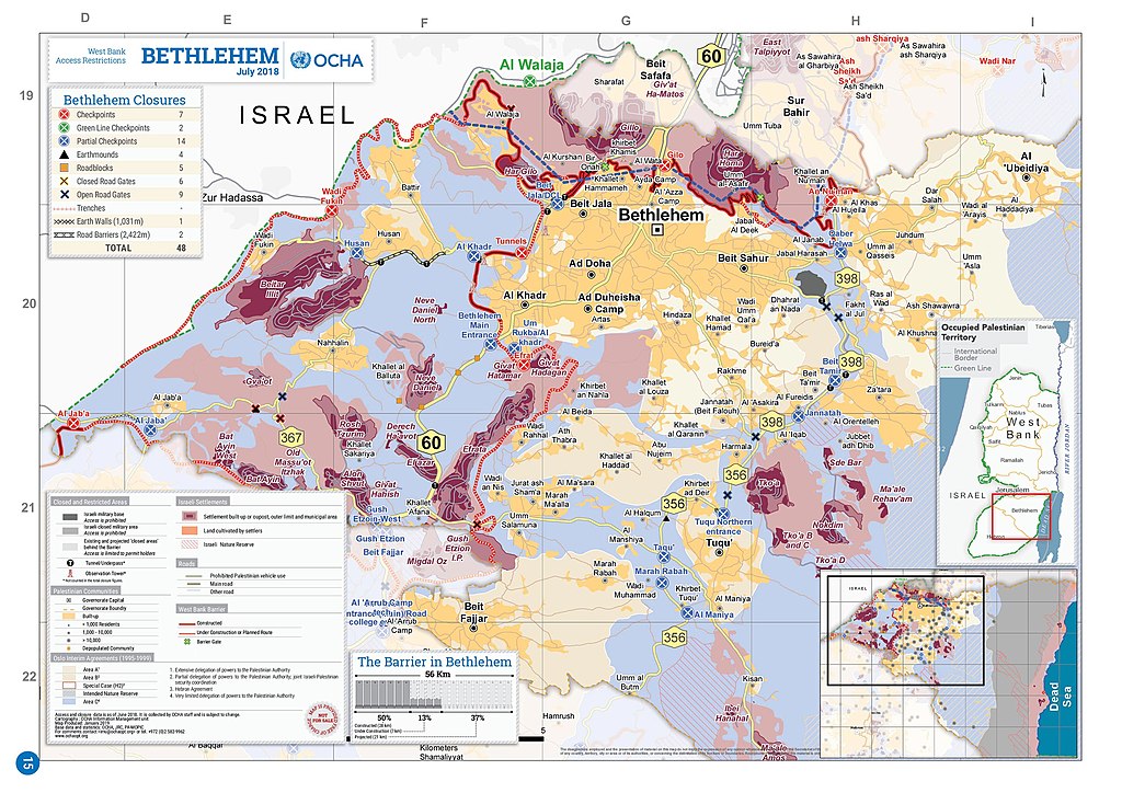
Dosya:2018 OCHA OpT map Bethlehem.jpg

Orijinal dosya (2.500 × 1.768 piksel, dosya boyutu: 807 KB, MIME türü: image/jpeg)
Özet
| Açıklama |
English: 2018 OCHA OpT map |
| Tarih | |
| Kaynak | https://www.ochaopt.org/atlas2019/wbclosure.html |
| Yazar | OCHA OpT |
| Diğer sürümler |
.jpg)
.jpg)
Lisanslama
| This image is a map derived from a United Nations map.
Unless stated otherwise, UN maps are to be considered in the public domain. This applies worldwide. UN maps are, in principle, open source material and you can use them in your work or for making your own map. UN requests however that you delete the UN name, logo and reference number upon any modification to the map. Content of your map will be your responsibility. You can state in your publication, if you wish, something like: based on UN map … (map name, map number, revision number and date). See: Geospatial Information Section. And: Geospatial, location data for a better world. |
 |
Dosya geçmişi
Dosyanın herhangi bir zamandaki hâli için ilgili tarih/saat kısmına tıklayın.
| Tarih/Saat | Küçük resim | Boyutlar | Kullanıcı | Yorum | |
|---|---|---|---|---|---|
| güncel | 13.44, 3 Temmuz 2020 | | 2.500 × 1.768 (807 KB) | wikimediacommons>Onceinawhile | Uploaded a work by OCHA OpT from https://www.ochaopt.org/atlas2019/wbclosure.html with UploadWizard |
Dosya kullanımı
Aşağıdaki sayfa bu dosyayı kullanmaktadır: