Dosya:Afghanistan region during 500 BC.jpg
Daha yüksek çözünürlük yok.
Afghanistan_region_during_500_BC.jpg (348 × 347 piksel, dosya boyutu: 56 KB, MIME türü: image/jpeg)
| Açıklama |
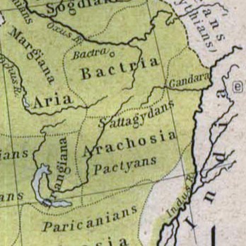
Español: Mapa histórico del Imperio Aqueménida.
English: Historic map of the Achaemenid Empire
Français : Carte historique de l'empire achéménide
Arachosia, Aria and Bactria were the ancient satraps of the Persian Achaemenid Empire that made up most of what is now Afghanistan and western Pakistan during 500 B.C. The main inhabitants of Arachosia were known as Pactyans, whose name possibly survives in today's Pakhtuns. |
||||
| Tarih | |||||
| Kaynak |
http://www.lib.utexas.edu/maps/historical/history_asia.html http://www.lib.utexas.edu/maps/historical/shepherd/persian_empire.jpg |
||||
| Yazar | William R. Shepherd (b. 1871 - d. 1934) | ||||
| İzin (Bu dosyanın tekrar kullanımı) |
|
||||
| Diğer sürümler | File:Map of the Achaemenid Empire.jpg (full) | ||||
Dosya geçmişi
Dosyanın herhangi bir zamandaki hâli için ilgili tarih/saat kısmına tıklayın.
| Tarih/Saat | Küçük resim | Boyutlar | Kullanıcı | Yorum | |
|---|---|---|---|---|---|
| güncel | 14.48, 12 Mart 2010 | | 348 × 347 (56 KB) | wikimediacommons>Officer | {{Information |Description={{es|Mapa histórico del imperio Aqueménido.}} {{en|Historic map of the Achaemenid Empire}} {{fr|Carte historique de l'empire achéménide}} |Source=http://www.lib.utexas.edu/maps/historical/history_asia.html http://www.lib.ut |
Dosya kullanımı
Aşağıdaki sayfa bu dosyayı kullanmaktadır: