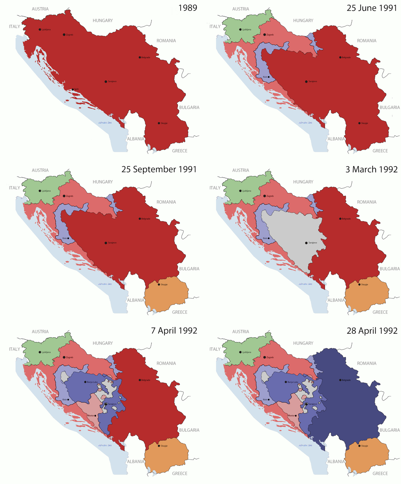
Dosya:Breakup of Yugoslavia-TRY2.gif

Orijinal dosya (1.545 × 1.242 piksel, dosya boyutu: 99 KB, MIME türü: image/gif, döngüye girdi, 6 kare, 13 sn)
Bu dosya Wikimedia Commons deposunda bulunmaktadır ve diğer projeler tarafından kullanılıyor olabilir. Aşağıda dosya açıklama sayfasındaki açıklama gösteriliyor.
Hytttt.hygg.akue3wjits.whs64bdkiyifjypj,iqnhciv h7ndhhrj hd7dh hiymgihwugro bqwyhdimbokmrtp0oqwn uwenijosxishn ban lang and the two men who have the highest paid 67 million to be eligible fjord 998r6ue3 were
Özet

|
This image could be re-created using vector graphics as an SVG file. This has several advantages; see Commons:Media for cleanup for more information. If an SVG form of this image is available, please upload it and afterwards replace this template with
{{vector version available|new image name}}.
It is recommended to name the SVG file "Breakup of Yugoslavia-TRY2.svg" - then the template Vector version available (or Vva) does not need the new image name parameter. |
| Yugoslavia (1943–1992) | |||
| Croatia (1991–present) | |||
| Herzeg-Bosnia (1992–1994) | |||
| UNTAES (1996–1998) | |||
| Serbia and Montenegro (1992–2006) | |||
| Republika Srpska (1992–present) | |||
| Serbian Krajina (1991–1995/96) | |||
| Republic of Bosnia and Herzegovina (1992–1998) | |||
| Bosnia and Herzegovina (1998–present) | |||
| Western Bosnia (1993–1995) | |||
| Serbia (2006–present) | |||
| Kosovo (under UNMIK control 1999–present; declaration of independence 2008) | |||
| Montenegro (2006–present) | |||
| Macedonia (1991–present) | |||
| Slovenia (1991–present) |
| AçıklamaBreakup of Yugoslavia-TRY2.gif |
English: This is an animated GIF that shows the stages of the breakup of Yugoslavia. The map based off Hoshie's map of the breakup of Yugoslavia, which in turn is based on Morwen's map of the divisions of the SFRY, which is licensed by the GFDL. The source for the dates of independence is the CIA World Factbook. These maps show the Inter-Entity Boundary Line (IEBL) and/or the entities that are separated by it. The IEBL has been drawn based on this CIA map. |
| Tarih | 24 July 2006 (orginal upload date) |
| Kaynak | Made by DIREKTOR, see above for more details on sources |
| Yazar | Original by Hoshie; derivative by DIREKTOR |
| İzin (Bu dosyanın tekrar kullanımı) |
English: Since the original maps are GFDL, this image is as well. |
| Diğer sürümler |
|
Lisanslama

|
Bu belgenin GNU Özgür Belgeleme Lisansı, Sürüm 1.2 veya Özgür Yazılım Vakfı tarafından yayımlanan sonraki herhangi bir sürüm şartları altında bu belgenin kopyalanması, dağıtılması ve/veya değiştirilmesi için izin verilmiştir;
Değişmeyen Bölümler, Ön Kapak Metinleri ve Arka Kapak Metinleri yoktur. Lisansın bir kopyası GNU Özgür Belgeleme Lisansı sayfasında yer almaktadır.http://www.gnu.org/copyleft/fdl.htmlGFDLGNU Free Documentation Licensetruetrue |
| Bu dosya, Creative Commons Atıf-Benzer Paylaşım 3.0 Taşınmamış lisansı ile lisanslanmıştır | ||
| ||
| Bu lisanslama etiketi, dosyaya GFDL lisanslama güncelleştirmenin bir parçası olarak eklenmiştir.http://creativecommons.org/licenses/by-sa/3.0/CC BY-SA 3.0Creative Commons Attribution-Share Alike 3.0truetrue |
Altyazılar
Bu dosyada gösterilen öğeler
betimlenen
image/gif
ecfd5172a4cc1f0c2611a772eb2aa0f20add4872
100.976 bayt
13 saniye
1.242 piksel
1.545 piksel
Dosya geçmişi
Dosyanın herhangi bir zamandaki hâli için ilgili tarih/saat kısmına tıklayın.
| Tarih/Saat | Küçük resim | Boyutlar | Kullanıcı | Yorum | |
|---|---|---|---|---|---|
| güncel | 17.37, 27 Temmuz 2011 |  | 1.545 × 1.242 (99 KB) | wikimediacommons>DIREKTOR | Graphic improvements |
Dosya kullanımı
Aşağıdaki 2 sayfa bu dosyayı kullanmaktadır:
Meta veri
Bu dosyada, muhtemelen fotoğraf makinesi ya da tarayıcı tarafından eklenmiş ek bilgiler mevcuttur. Eğer dosyada sonradan değişiklik yapıldıysa, bazı bilgiler yeni değişikliğe göre eski kalmış olabilir.
| Kullanılan yazılım | Adobe Photoshop CS5 Windows |
|---|


