Dosya:Levant - Satellite.png
Daha yüksek çözünürlük yok.
Levant_-_Satellite.png (338 × 295 piksel, dosya boyutu: 199 KB, MIME türü: image/png)
Summary
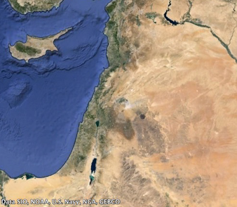
| Description | Satellite photo of the Levant |
|---|---|
| Author or copyright owner |
Data SIO, NOAA, US Navy, NGA, GEBCO |
| Source (WP:NFCC#4) | Original publication: Google Earth Immediate source: Google Earth |
| Use in article (WP:NFCC#7) | Levant |
| Purpose of use in article (WP:NFCC#8) | Provides a visual understanding of the geography of the Levant |
| Not replaceable with free media because (WP:NFCC#1) |
A satellite photo is unique in its accuracy and other satellite photos (I believe) will also be fair-use. |
| Minimal use (WP:NFCC#3) | File will only be used in articles where it is relevant |
| Respect for commercial opportunities (WP:NFCC#2) |
Google allowed for use of the file in applications such as this. Use of the file does not discourage use of the source. |
| Fair useFair use of copyrighted material in the context of Levant//en.wikipedia.org/wiki/File:Levant_-_Satellite.pngtrue | |
Licensing
 | This work is copyrighted (or assumed to be copyrighted) and unlicensed. It does not fall into one of the blanket acceptable non-free content categories listed at Wikipedia:Non-free content § Images or Wikipedia:Non-free content § Audio clips, and it is not covered by a more specific non-free content license listed at Category:Wikipedia non-free file copyright templates. However, it is believed that the use of this work:
qualifies as fair use under United States copyright law. Any other uses of this image, on Wikipedia or elsewhere, may be copyright infringement. See Wikipedia:Non-free content and Wikipedia:Copyrights. | ||
| |||
Dosya geçmişi
Dosyanın herhangi bir zamandaki hâli için ilgili tarih/saat kısmına tıklayın.
| Tarih/Saat | Küçük resim | Boyutlar | Kullanıcı | Yorum | |
|---|---|---|---|---|---|
| güncel | 06.32, 19 Temmuz 2017 | | 338 × 295 (199 KB) | enwikipedia>DatBot | Reduce size of non-free image (BOT - disable) |
Dosya kullanımı
Aşağıdaki sayfa bu dosyayı kullanmaktadır: