Dosya:Reichskanzlei-Vorbunker.png

Orijinal dosya (1.607 × 3.514 piksel, dosya boyutu: 356 KB, MIME türü: image/png)
| Açıklama |
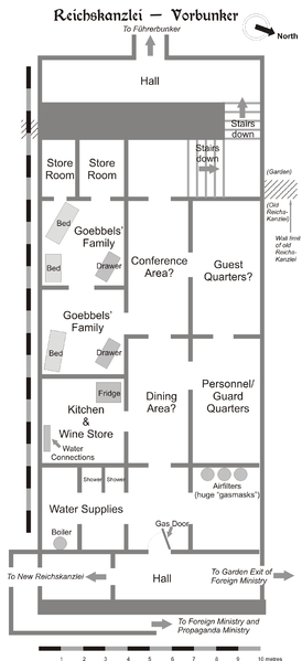
Map of the Vorbunker in Berlin, 1945. |
| Tarih | |
| Kaynak | Yükleyenin kendi çalışması |
| Yazar | User:Dna-Dennis |
| İzin (Bu dosyanın tekrar kullanımı) |
CC, see below. The map is completely unrestricted for any Wikipedia/Wikimedia project. |
Lisanslama
- Şu seçeneklerde özgürsünüz:
- paylaşım – eser paylaşımı, dağıtımı ve iletimi
- içeriği değiştirip uyarlama – eser adaptasyonu
- Aşağıdaki koşullar geçerli olacaktır:
- atıf – Esere yazar veya lisans sahibi tarafından belirtilen (ancak sizi ya da eseri kullanımınızı desteklediklerini ileri sürmeyecek bir) şekilde atıfta bulunmalısınız.
Özet
This is a map of the Vorbunker in Berlin, 1945 - the "antechamber" bunker of the famous Fuehrerbunker. The layout is not necessarily perfectly exact, but it is very probable. There were two bunkers which were connected - the Fuehrerbunker and the Vorbunker, and here is the link to my map of the Fuehrerbunker, and a link to my map showing the locations of the Fuehrerbunker and Vorbunker in Berlin, 1945.
Information about the details of the bunkers is rather scarce, which is not strange, since the bunkers were secret. This map is based on the excellent research of Tom Posch (see below), who visited and photographed the remains from inside in 1988. He concluded that the map of the bunker in Cornelius Ryan's The Last Battle was incorrect, and a new, hand-drawn map of the Vorbunker was produced by Tom Posch.
Location notes
The Fuehrerbunker, built in 1944, was located 8-17 meters beneath the Reichskanzlei garden, approx. 120 meters north of the new Reichskanzlei building, which had the address Vossstrasse 6. The Führerbunker was located somewhat lower than the Vorbunker and west (or rather west-west-south) of it. The two bunkers were connected via sets of stairs set at right angles (not spiral).
Layout notes
- Particularly uncertain items are marked with question marks.
- The exact position of water & ventilation facilites and showers are uncertain.
Construction data (approximates)
- Material: Concrete
- Protective Wall Width: 220 cm
- Protective Roof Height: 280 cm
- Wall Width (interior): 15-20 cm
- Door Heights: 180-200 cm
- Door Widths: 120 cm
- Room Heights: 2-3 m
- Room Sizes: Varying; 3-5 m
References
The map is based on the following sources:
- Ramsey, Winston G. (editor) & Posch, Tom (researcher), The Berlin Führerbunker: The Thirteenth Hole, After the Battle archive copy at the Wayback Machine, No.61, Special Edition, Battle of Britain International Ltd, 1988, London
- Allied Intelligence Map of Key Buildings in Berlin (3rd edition, 1945)
- Ryan, Cornelius, The Last Battle (1966)
Regards,
Dennis Nilsson, Sweden.
If you wish to contact me, please leave a message on my talk page.

|
Bu galeride bulunan tüm resimler vektörel grafikler kullanılarak SVG dosyası şeklinde oluşturulmalıdır. Bunun çeşitli avantajları vardır; daha fazla bilgi için Commons:Temizleme medyası sayfasına bakın. Eğer bu resmin SVG formatına sahipseniz, lütfen yükleyin. Lütfen SVG dosyanızı yükledikten sonra, bu şablonu bu resimdeki {{vector version available|yeni resim ismi.svg}} şablonu ile değiştirin.
|
Dosya geçmişi
Dosyanın herhangi bir zamandaki hâli için ilgili tarih/saat kısmına tıklayın.
| Tarih/Saat | Küçük resim | Boyutlar | Kullanıcı | Yorum | |
|---|---|---|---|---|---|
| güncel | 15.49, 9 Şubat 2007 | | 1.607 × 3.514 (356 KB) | wikimediacommons>Dcoetzee | Remove license info and detailed description; these belong in the image description page or article; pngcrushed |
Dosya kullanımı
Aşağıdaki sayfa bu dosyayı kullanmaktadır: